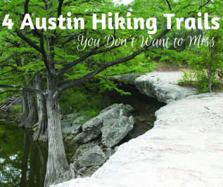
 © Aburtwk | Dreamstime.com - McKinney Falls Texas State Park Photo
It’s hard to believe how much natural beauty, unspoiled ecological wonders, and seclusion you can find within the city limits of Austin. When you just have to get away from the cosmopolitan rush to commune with nature, you don’t have to travel far to explore the exquisite tranquility along these hiking trails.
Barton Creek Greenbelt
Considered the 7th best hiking trail in Texas, Barton Creek Greenbelt has several access points that will take you through its 809-acre Wilderness Park located in the Southwest part of the city. It’s filled with swimming holes and lush greenery, with moderate to at times challenging sections. You won’t believe you’re minutes from the highway and shopping centers.
Enter at the center of the trail by Loop 360 (Capitol of Texas Highway), the main access point where parking is available along the highway. To the west, from Camp Craft Road is the entrance to the Twin Falls trail where you can gaze at and splash in a spectacular waterfall. This trail is used by hikers as well as mountain bikers and trail runners (5 miles, moderate). Dogs are allowed on leashes.
Or begin your trek of the 7.9 mile loop at Zilker Park on the east end, where additional parking is available. If you pay close attention you might see the remains of dinosaurs among the botanical gardens.
The Sculpture Falls trail (3 miles, moderate difficulty), which follows Barton Creek, is on the southern end of the greenbelt. It’s well shaded, offers many swimming spots and a waterfall, creeks for dipping, limestone cliffs for rock climbing, caves, old live oaks and a variety of wildlife. It’s slippery so bring your water shoes. Dogs allowed.
Wild Basin Trail
If you’re up for a serious hike or want to take a leisurely stroll, you can do either at Wild Basin. Hike along 2.5 miles of trails among scrubby oak and juniper woodlands that form deep pockets of dense forest. It should only take about an hour. Here you may come across an endangered species, the golden-cheeked warbler, the only place in the world where this bird lives and breeds. You’ll cross over woodlands, grasslands, and streams, and find an outcropping of large limestone rocks that are riddled with interesting tunnels and holes that form the fossils of animal trails.
View the Edwards Plateau in the hills above the trail from the scenic overlook, which is commonly called the Texas Hill Country. Creeks and rivers flow across the plateau, which over the years have cut through layers of limestone to form the hills, terraces, and ravines of the Balcones Canyonlands. Stop for a view of the falls at Bee Creek, the main waterway that flows through the preserve, which supports many types of plant and animal life.
Wild Basin is also home to the Creative Research Center, owned and operated by St. Edwards University, which supports student education and research about the preserve as well as acting as a public visitor’s and information center. Enter Wild Basin on the east side of Loop 360 (805 N. Capital of Texas Highway), approximately 1 mile north of Bee Caves Road or 3 miles south of the Loop 360 bridge over Lake Austin. Keep your dog and bike at home for this excursion.
River Place Nature Trail
Waterfalls, fantastic views, and challenging climbs describe what you’ll encounter on the River Place Nature Trail, off of Big View Dr. in the River Place area. Austinites might know River Place Nature Trail by its original name, Panther Hollow Trail.
The first part of this 3.5-mile trail is an easy walk, as you follow a pond teeming with turtles and sidelined by occasional anglers. But then it gets challenging as the path disappears into uphill brush. Hikers and trail runners and on-leash dogs on this trek are okay, but no mountain biking.
If you’re just up for a leisurely stroll, some hikers have suggested a shortcut where you go down by the sidewalk of River Place Blvd to the Uplands Nature Trailhead (about a mile) and then take that trail back to Woodlands Park. Woodlands Park has bathrooms with toilets and sinks with running water. There is also a small parking lot.
The northern section reveals vista views of the surrounding canyon and the golf club below. This segment of the trail, Upper Panther Trail and Canyon Trail, offers the biggest variations in elevation. You’ll be ascending and descending out of creek beds and ravines for a good workout. There are some spots with overlooks, but views are mostly obscured by trees and brush. It ends at River Place Blvd, which does not have parking but does have some space along the road to leave your vehicle.
McKinney Falls State Park Trails
The 725-acre state park has some inviting trails, beautiful waterfalls, Indian rock shelters and pioneer ruins to explore, not to mention it is home to over 225 species of birds. You can come for the day or make it an overnight stay in your camper.
Off McKinney Falls Parkway, in southeast Austin, the park offers three trails to give hikers a choice of different elevation challenges and surface terrain. There’s ample parking, picnicking, and restrooms within the park.
The Rock Shelter Trail (.90 miles) starts and ends at Smith Visitor Center. You’ll be making a 60-foot elevation change as you explore limestone cliffs that have supported life and given shelter to its residents and wildlife for over 8,000 years. This one is for hiking only. Note a portion of the trail was closed in 2013 due to flooding, which may not have reopened.
Onion Creek Hike and Bike Trail (2.8 miles) also starts and finishes at the Smith Visitor Center. You’ll experience an elevation change of 139 feet when you complete the trek on a surface of man-made tarmac. There’s a picnic area within the first half mile. When you’ve reached about the last half mile, you’ll see the remains of breeding and exercise pastures and a cabin used by the park’s horse trainer back in the 1850s. Most of the park’s wildflowers are on this trail.
Homestead Trail starts and finishes on the north side of Onion Creek (2.75 miles). You’ll experience an elevation change of 117 feet. Hop across rocks in the creek near the edge of the falls. Much of the path sits on a huge rock outcropping. Along this trail are the remains of a house owned by the park’s namesake, Thomas McKinney. Thomas McKinney, by the way, was one of Stephen F. Austin’s original colonists. The trail itself is a mixture of easy meandering flat jeep roads and single track terrain flanked by trees and grasses.
Maps, Parking and Must-See Spots
Check these websites for detailed maps, access and parking points, and all the not-to-be-missed swimming holes, and scenic vistas of these and other hiking locales:
- https://austintexas.gov/page/trail-directory
- https://austinparks.org/parks/
- https://alltrails.com/us/texas/austin
